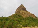
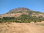
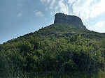
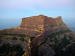
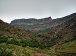
Achala Fort / अचला किल्ला is a westernmost fort in the Satmala hill range. It is located 55km from Nashik, in Nashik district, of Maharashtra. This fort is adjoining the Ahivant Fort. The three forts Achala, Ahivant, and Mohandar are very close by. The Achala and Mohandar forts were constructed to guard the Ahivant fort. Captain Briggs has described it as a large hill, whose ascent is very easy till it reaches the top where it is very steep.
History
In 1636 this fort was under the control of Adilshah. The Moghul Emperor Shahjahan send one of his General Shaista Khan and entrusted to win all the forts in Nashik region. Alivardikhan was cavalier of Shaista Khan who won the Fort. In 1670 king Shivaji won the fort from Moghuls. The Moghul Emperor Aurangzeb sent his chieftain Mahabat Khan to win the fort. Mahabat Khan and DilerKhan opened battle front from either side of the fort. The attack was so fierce that the Ahivant fort was surrendered to Moghuls.Subsequently, the Achala fort was also surrendered. In 1818 the fort was surrendered to Colonel Briggs along with other 17 forts after the fall of Trymbak fort.
How to reach
The nearest town is Vani which is 44 km from Nashik. The base village of the fort is Dagad Pimpri which is 13km from Vani. There are good hotels at Vani. The trekking path starts from the hillock north of the Dagad Pimpri. The route is very safe and wide. There are no trees on the trekking route. It takes about one hour to reach the col between the two forts. The right path goes to Ahivant fort and the left path goes to Achala fort. The night stay on the fort cannot be made due to lack of potable water on the fort. The villagers from the local village make night stay and food arrangements at a reasonable cost.The other route is from Village Daregaon
Places to see
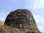
The Achala fort is occupied on a small hill. There are few ruins of buildings, store houses and water tanks that can be seen on the fort. It takes about half an hour to encircle the fort.
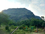
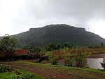
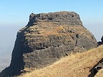
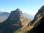
 Ahivant Fort / अहिवंत किल्ला is a fort located 55km from Nashik,in Nashik district, of Maharashtra. This fort is an important fort in Nashik district. The three forts Achala, Ahivant, and Mohandar are very close by. The other two forts were constructed to guard the Ahivant fort. Captain Briggs has described it as a large and shapeless hill, remarkably bleak and unhealthy.
History
In 1636 this fort was under the control of Adilshah. The Moghul Emperor Shahjahan send one of his General Shaista Khan and entrusted to win all the forts in Nashik region. Alivardikhan was cavalier of Shaista Khan who won the Fort. In 1670 king Shivaji won the fort from Moghuls. The Moghul Emperor Aurangzeb sent his chieftain Mahabat Khan to win the fort. Mahabat Khan and DilerKhan opened battle front from either side of the fort. The attack was so fierce that the fort was surrendered to Moghuls. In 1818 the fort was captured by British Colonel Prother.
How to reach
The nearest town is Vani which is 44 km from Nashik. The base village of the fort is Dagad Pimpri which is 13km from Vani. There are good hotels at Vani. The trekking path starts from the hillock north of the Dagad Pimpri. The route is very safe and wide. There are no trees on the trekking route. It takes about two hours to reach the entrance gate of the fort. The night stay on the fort cannot be made due to lack of potable water on the fort. The villagers from the local village make night stay and food arrangements at a reasonable cost.The other route is from Village Daregaon
Places to see
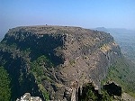
The Ahivant fort is occupied on a large flat plateau. All the structures are in ruined state.The ruins of sore houses and arches can be seen on the fort. There are some bastions and water cisterns on the fort to be seen. It takes about one hour to encircle the fort.
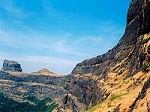 Alang Fort / अलंग किल्ला is a fort in Nashik district, Maharashtra, India. It is one of the three forts, the others being Madangad and Kulang, in the Kalsubai range of the Western Ghats. They are the most difficult to reach forts in Nasik District. A dense forest cover make these treks difficult. These three forts are a little neglected due to very heavy rains in the area and a difficult confusing path to the forts.
How to reach
To reach Alang, go to Kasara or Igatpuri and then Ambevadi by the Igatpuri/Kasara-Ghoti-Pimpalnermor route. There is a bus service from Ghoti to Ambevadi. Ambevadi is 32 km away from Ghoti. A bus is available at 6 a.m. from Ghoti to Ambevadi. We can easily see Alang, Madan and Kulang from there. From Ambevadi, a way goes to the ridge between Alang and Madan, which may take up to 3 hours. From the ridge, the fort visible on the left is Alang, while the one on the right is Madan. From there, two ways go towards Alang. a) One way descends from the ridge. Within 1 hour you can reach the plateau. Keeping Alang to your left, you will reach a cavern after about an hour’s walk. From there, you can go higher by rock climbing. Then you will reach a flat patch. Keep left and proceed towards the pinnacle. After 10 to 15 minutes, you will come at a cave in the fort. Time required to reach here from Ambevadi is approximately 8 to 9 hours. b) Proceed from the ridge and after easy rock climbing, you will come near few steps. After ascending these steps, climb a broken pinnacle of 80 to 90 ft. Only trained climbers should go this way. This way, you can reach the fort after 6 hours.
Places to see
The top of the fort is a huge plateau. On the fort, there are two caves, a small temple and 11 water cisterns. Remnants of buildings are spread over the fort. Kalasubai, Aundh Fort, Patta and Bitangad are to the east of the fort, Harihar, Trymbakgad and Anjaneri to its north and Harishchandragad, Aajobagad, Khutta (pinnacle), Ratangad and Katrabai to its south.
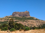
 Ankai Fort अंकाई / अणकाई is found in the Satmala Range hills, alongside a large Maratha hill fort on the peak. It is located in Yeola Taluka of Nashik district in Maharashtra, India. It lies close to the Manmad. The Ankai fort and Tankai fort are two forts on adjacent hills. The common fortification is constructed to secure both. The Ankai fort is located on a hill with perpendicular scarp on all the sides, except for a narrow nose on the eastern side.
History
The Brahmani (Hindu) caves on the fort and the Jain caves at the base of the fort depict that Ankai was constructed roughly 1000 years ago. The fort was built by Yadava of Devgiri. Mughals led by Shah Jahan’s General Khan Khanan captured this fort in 1635 by bribing the fort commander. In 1665, Thevenot mentions these forts as a stage between Surat and Aurangabad.[3] Ankai was ultimately captured by Nizam from Mughuls. In 1752, the fort came under the control of Maratha empire after the treaty of Bhalki. Finally, it was captured by the British in 1818.
How to reach
The nearest town is Manmad which is 97 km from Nashik. The base village of the fort is Ankai which is 10 km from Manmad. There are three routes to reach Ankai from Nashik. The shortest and safest is via Manmad, the other two are via Vinchur-Lasalgaon-Patoda (85 km) and via Yeola (108 km). There are good hotels at Manmad, tea and snacks are now also available in small hotels on the highway. The Ankai railway station is very close to the village. All the passenger trains passing on the Manmad-Nizamabad route stop on the railway station. The trekking path starts from the hillock north of the Ankai village. The route is very safe and wide. There are regular steps to the fort. There are no trees on the trekking route and on the forts. It takes about half an hour to reach the entrance gate of the fort. An overnight stay at Ankai can be made in the temple. The villagers from the town offer supplies for the trip. It takes about 3 hours to see both the forts. It is advisable to first visit the Ankai fort in the early hours of the day and complete the Tankai fort before noon.
Places to see
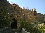
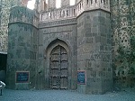
Jain caves located in the foot hills of the fort, spanning two stories. On the lower story there are two caves, neither of which have idols. On the upper story, there are five caves which feature Mahavir idols in good condition. They are secured by lock and key during night time to avoid vandalism. There is rock cut potable water cisterns at the entrance of the caves. There are carvings of Yaksha, Indrani, lotus and Lord Mahavir in the main cave. In the third cave, there are idols of Kichaka and Ambika. · Main Gate The main gate is located on the South of the hill, featuring well preserved wooden woodwork. · Manmad Gate This gate is on the Northern side of the col facing Manmad city. · Brahmani (Hindu) Caves These caves are near the entrance gate to the upper plateau of Anakai fort. They are in ruins, but the idols of Jai and Vijay carved out of rock and the Shivinga can still be seen. · The rock cut steps Rock cut steps and four gates which must be passed through to reach the top most plateau of the fort. · The Palace and Kashi pond On the western edge of the plateau is a large palace in a dilapidated condition. Only the walls of the palace remain. There is a single Darga room in the palace. Among the rock cut cisterns on the way to the palace is the Kashi pond, with a holy Tulsi pot engraved in rock placed in the center of the pond. There is a series of rock-cut water cisterns on the southern side of the fort. It takes about two hours to visit all places on the fort.
 Bhaskargad fort / Basgad Fort is a fort located 48 km from Igatpuri, Nashik district, of Maharashtra. This fort is one of the fort in Trimbak hill range. This fort is near to the Harihar fort
History
This fort was built during the period of Yadava of Deogiri. It was under control of Yadavas from 1279 to 1308. It was later under the control of Bahamani Sultanate followed by Nizamshahi of Ahmednagar. In 1629 Shahaji Raje revolted against the Mohammed Adil Shah of Bijapur and the fort was captured by him.This fort was again captured by Adil Shah after the surrender of Shahaji at Mahuli Fort. This fort was under Mughals in 1633. in 1670 the Chieftain of Shivaji Maharaj, Moropant Pingale won the fort from Moghuls.[1] In 1688 the fort was again captured by Moghuls. The Koli tribals revolted in 1730 and captured the fort. This fort was under the control of Peshwas till in 1818 when Captain Briggs of East India Company captured it.
How to reach
There are two routes to reach the base village Dahalepada. One route is from Khodala and the other from Igatpuri.The nearest town is Igatpuri which is 48 km from Nashik and 121 km from Mumbai. The base village of the fort is Dahalepada which is 48 km from Igatpuri. There are good hotels at Igatpuri and Ghoti. The trekking path starts from the hillock south of the Dahlepada. The route is very safe and wide. The trekking route passes through scrub forest till it reaches an open ridge which is connected to the fort. It takes about an hour to reach the scarp of the hill on which the fort is situated.The route then take a long traverse behind the hillock. There are many overhangs on the scarp. The traverse is very safe and passes through Karvi shrubs till it reaches the rock cut steps. The climb on the steps is very easy. The parent rock is cut in helical shape and the steps are carved out of it. The half of the path is now covered with boulders and stones. It takes about 15 minutes to reach the top of the fort. The night stay on the fort cannot be made since there is no water and no accommodation facility. It is advised to carry enough water for this trek since there is no water on the route and on the fort.
Places to see
There is one main gate on the main entrance path of the fort.The main entrance gate and the rock cut steps are carved in the same rock. There is a rock cut water cistern on the fort. There is a rough idols of Veer Maruti on the fort. It takes about half an hour to visit all places on the fort.
 Chandwad Fort (Chandor fort; चांदवड किल्ला) is located 10 km from Chandwad, Nashik district, of Maharashtra.
History
Chandwad fort was positioned to overlook the trade route from Khandesh to Nashik. It guarded the Chandor pass in the nearby hills. It was built about A.D. 801 by Dridhaprahara, the founder of the Chandor Yadava Dynasty (A.D 801-1073). King Bhoj established 52 temples in the nearby region. His daughter, Chandrakala, was married to King Vikram at this fort.The fort was under the control of the Bahmani Sultanate in 14th century. In 1635 the Moghul army took Chandor fort along with Indrai fort. In 1665 Chanwad fort was taken by the Maratha Empire.[1] It was later captured by the Moghul emperor, Aurangzeb. Between 1754 and 1756, Malharrao Holkar induced craftsman to settle in the town by gifting some land. Chandwad then became famous for its brass-work. On 10th April 1818, after the surrender of Ankai and Tankai forts, the British forces captured Chanwad fort under the detachment headed by Lieutenant-Colonel McDowell. In 1857, during the first war of independence (the rebellion), the 24th Maratha regiment initially took charge of the fort, but had to surrender it to British forces in 1859. After the opening in 1861 of the G.I.P. Railway depot at Manmad, the bulk of trade line traffic was diverted away from Chandwad.
 Galna (Marathi: गाळणा क़िल्ला, Hindi: गालना क़िला) was a major fort in the south Khandesh area of Maharashtra, India. This fort was an important fort on the Burhanpur -Surat trade route. This is one of the forts in Maharashtra with the bastion and the entrance in good condition. This fort is located on hills between Malegaon and Dhule.
History
Galna was an important place at the end of the fifteenth century. It lay on the border of the Deccan. It was held by the Maratha when about in 1487, two brothers Malik Wuji and malik Ashraf, the Governors of Daulatabad took it and held for some time. In 1506 after the murder of Malik Wauji the fort was under the control of Malik Ahmed Shah Nizam of Ahmadnagar. On the death of Malik Ahmed Shah Nizam of Ahmadnagar on 1510 again the fort was passed to Musalman chief who denied to pay tributes to Maratha chief. In 1634 Muhammad khan, the Musalman commandant of Galna delivered their tributes to Moghuls. It was attacked by Aurangzeb in 1704 and captured in 1705. In December 1804 this fort was taken from Holkars by Captain Wallace. Finally, in March 1818 it was occupied by native Infantry.For a few year after 1818, a mamlatdar held an office in Galna.
How to reach
This fort is located in Malegaon taluka of Nashik district. The base village Galna is well connected by motorable road to Malegaon and Dhule.Regular buses ply from Malegaon to Dongarale village. Dongarale village is 30-15 km from Malegaon as well as Dhule. Dongarale to Galna distance is 4 km.
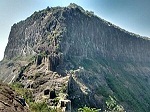
 Harihar fort / Harshagad is a fort located 48 km from Igatpuri, Nashik district, of Maharashtra. It is an important fort in Nashik district, and was constructed to look upon the trade route through Gonda Ghat. It receives many visitors because of its peculiar rock-cut steps.
History
Harihar fort was built during the Yadava period. It was surrendered by Shahaji Raje Bhosale to Khan Zamam in 1636 along with Trymbak and other Poona forts. The fort was captured by Captain. Briggs in 1818 along with other 17 forts.
How to reach
There are two base villages of the fort, Harshewadi and Nirgudpada. The Harshewadi is 13 km from Trymbakeshwar.The other base village of the fort is Nirgudpada/Kotamvadi which is 48 km from Igatpuri which itself is 48 km from Nashik and 121 km from Mumbai. The climb from Harshewadi is more easier than from the Nirgudpada.A wide, safe trekking path starts from the hillock north of the Nirgudpada. It passes through scrub forest till it reaches an open ridge which is connected to the fort. It takes about an hour to reach the scarp of the hill on which the fort is situated.The ascend through the 60 mtr rock cut steps is wonderful. It is like a stone ladder placed at 60 degree along the scarp.The steps are worn out at many places yet the holes on either side of the steps are conveniently cut for holding onto.After reaching the main entrance, the paths takes a left traverse and again a helical rock cut steps are to be climbed, which are more steep than the earlier. the steps finally end with a narrow entrance.At many places the steps are very narrow that, only a single person can climb at a time.Accommodation is possible on the fort as well as in the local villages.
 Indrai Fort / Indragiri Fort is a fort located 75 km from Nashik,in Nashik district, of Maharashtra. This fort though is an important fort in Nashik district but, it is less visited by the trekkers.In Chandwad taluka, there are 4 forts in a line on the Satmal hill range, the Chandwad fort, Indrai fort, Rajdher fort and Koldher fort. This fort is easy to climb, but requires 3 hours to reach the fort.
History
Much less history about this fort is known. This fort was surrendered to Captain Mackintosh in 1818, after the garrison in the fort saw burning of the neighbouring Rajdher fort.
How to reach
The nearest town is Chandwad which is 69 km from Nashik. The base village of the fort is Indraiwadi which is 9 km from Chandwad. There are good hotels at Chandwad, now tea and snacks are also available in small hotels at Indraiwadi. The trekking path starts from the hillock south of the Indraiwadi village. The route is very safe and passes through dense scrubs. There is no marked path which leads to the fort. it is advisible to hire a local guide from the village. It takes about two hours to reach the scarp of the fort. a narrow path along the base of the scarp takes a northern detour to reach the rock cut steps. The steps are 2m wide and 150 in number. It takes about 15 minutes to climb the steps. The entrance gate is nowhere seen. There is plenty of water available on the fort. The night stay on the fort can be made in the caves on the fort.
Places to see
The rock cut steps form a valley which lead to the fort. A rock cut inscription in Persian language is seen on the walls on the entrance. There are many rock cut water cisterns on the fort. The Kacheri, the Mahadev temple and 10 rock cut caves are the places to be seen. It takes about one hour to visit all places on the fort.
 Tringalwadi fort is located in the Igatpuri taluka of Nashik district. It is located on the ancient trade route passing through Thal ghat. The fort is located near village Tringalwadi. The Tringalwadi irrigation dam which is close to the village was built in 1978.
History
The presence of the caves indicate that the caves and the fort might be constructed around 10th century. The fort was built to overlook the trade route which connected Konkan to Nashik area. In 1636 the Shahaji (father of king Shivaji) had to cede it to the Moghuls after the defeat at mahulifort. It is not known when Shivaji took control of this fort, but in 1688 this fort was won by Moghuls. It is one of the 16 forts which was surrendered to British in 1818 after the fall of Trymbakgad fort.
How to reach
The village Tringalwadi is located 7 km from Igatpuri. Igatpuri is located on Mumbai-nashik Railway route as well as National Highway NH 160. There are two routes to reach the village Tringalwadi from Igatpuri first one passes through Igatpuri town and the other is by taking a northern exit to NH160 at Ghoti, further passing through village Balayaduri. The Tringalwadi fort is located on a hill which runs north-south. It is a mesa rock formation. The climb is very easy and takes about 30 minutes to reach the top of the fort from the village.
Places to see
At the footshills of the fort is a cave called pandav leni with beautifully carved entrance and a stone idol of Rishabhanatha in the garbha gruha. The cave has a large sabha mandapa. the western entrance to the fort is a unique structure of architecture. The steps and the entrance gate is carved from a single rock. There is an idol of veerHanuman or maruti near the entrance gate and two sharabhaidols carved on the top of the entrance gate. On the fort are ruins of old buildings and a smallBhavanimata temple.There is a cave and a rock cut water cistern on the western side of the hillock on the fort.
 Kanchana Fort is a hill fort in the Nashik district of Maharashtra. The Kanchana Fort is located in the Ajantha-Saatmal Mountain range. The height of the hill in which the Kanchana Fort is located is 1368m or 4490 ft. Kalwan is the name of the village where the hill is situated.
 Kankrala is an ancient hill fort that occupies two hills in the Malegaon taluka of Nashik district.
History
This fort is situated south of Galna fort. Very little history is known about this fort. It was captured by the British under Colonel Wallace in 1818.
How to reach
The village Karanjgavhan is situated near the village Kankrala.There is a direct road from Malegaon via Vadgaon and Lendhane villages to Karanjgavhan ( distance 11 km). The other route is through the road from Zodage which is on NH-3. Zodage to Karanjgavhan distance is about 15 km.From Karanjgavhan the road to the village Kankrala is abouut 5 km. The cart road take a western detour from village Kankrala which leads to the temple near the fort. From the temple the fort is clearly visible. It takes about an hour to reach the fort top. There are no proper steps or path ways.
Places to see
There are many rock cut water cisterns on the top of the fort as well as in the rocks near the gate. The water near the gate is potable. There are few caves near the entrance. The entrance is in dilapidated condition.There are no structures on the fort except few ruins.
 Kulang fort (कुलंग गड ) is located in the Igatpuri area of Nashik district, on the western side of the Kalsubai hill range. This fort is adjacent to the Madangad and Alang forts, all of which were constructed to protect the Nashik-Kalyan ancient commercial road.
History
In 1760 the fort were probably ceded by the Moghuls to the Peshwa along with many other forts in the Nashik region. In 1818 Kulang along with the other nearby forts were captured by the British forces.[2] The British, however did not destroy the steps of this fort.
How to reach
There is a base village Ambevadi or Kurangwadi, from which it takes about two to three hours to reach the fort. The path passes through a dense forest area, the Kalsubai-Harishchandragad Wildlife Sanctuary.[3] There is potable water on the way and plenty of clean water on the fort. There are spacious caves on the fort which could accommodate up to 100 persons. There is no fuel wood on the fort, so it is preferable to carry fuel wood or a gas-stove from the base village.
Places to see
There is a base village Ambevadi or Kurangwadi, from which it takes about two to three hours to reach the fort. The path passes through a dense forest area, the Kalsubai-Harishchandragad Wildlife Sanctuary.[3] There is potable water on the way and plenty of clean water on the fort. There are spacious caves on the fort which could accommodate up to 100 persons. There is no fuel wood on the fort, so it is preferable to carry fuel wood or a gas-stove from the base village.
 Malegaon Fort / मालेगाव किल्ला is land fort located in the busy Malegaon town. It is located 104km from Nashik, in Nashik district, of Maharashtra. This fort is on the north bank of Mausam river which is a tributary of Girna river.
History
In 1740 this fort was constructed by Naro Shankar Raje Bahadur the general of Peshwa. He was appointed as an agent in Malwa[1].He was gifted 18 villages which included Malewadi. [2].The crafts men were brought from Surat and northern India to build the fort[3].It took about 25 years to build the fort.[4]. After the fort was completed the craftsmen settled in the town. In 1816 Dilawar Khan a Rohill sepoy first constrcted an Idgah in the town. After the fall of Trymbak fort on 24 May 1818, this fort was besieged on 16th May 1818 by the East India Company.
How to reach
The fort is located in the midst of Malegaon town. Malegaon town is located on the Mumbai-Agra National highway NH-60. The fort is also called as Raje Bahadur Wada.It is close to the Ramsetu bridge. The fort is open to the public between 10 am -5 pm. At present, there is a Marathi high school in the premises of the fort.
Places to see
The entire fort is in good condition. The height of the inner wall is 60 feet.The fort has lofty entrance doors. The thickness of the walls is about 6 feet. There are two cannons at the entrance door. there is a hexagonal well inside the fort. It takes about an hour to see the fort.
Mandan gad is a fort in the Nashik region of Maharashtra, India in the Kalsubai range.
How to reach
Igatpuri/Kasara-Ghoti-Pimpalnermor-Ambevadi route. First reach Kasara station which is on Nashik-Kalyan route. Take a cab for Rs. 1200/- which will drop you at Ambewadi or Samrad. From Samrad hire a local guide for Rs.1500/ per 10 persons. The guide will manage 2 breakfast, 3 meals and all necessary equipment( ropes, carabiners, harness etc.) for ascending and descending. Alang, Madan and Kulang are situated in same region and are beside each other in the same range of mountains. To reach Alang or Madan, go to Kasara or Igatpuri and then Ambevadi by the Igatpuri/Kasara-Ghoti-Pimpalnermor route. There is a bus service from Ghoti to Ambevadi. Ambevadi is 32 km away from Ghoti. A bus is available at 6 a.m. from Ghoti to Ambevadi. We can easily see Alang, Madan and Kulang from there. From Ambevadi, a way goes to the ridge between Alang and Madan, which may take up to 3 hours. From the ridge, the fort visible on the left is Alang, while the one on the right is Madan.It takes 2 to 3 hours to reach at the top of Madan from the col. There are three parts of climbing the Madan.
Places to see
Unlike Alang fort, top of the fort is a relatively small and tilted plateau. On the fort, there is a caves and 2 water cisterns. There are no man made structure, building remnants over the fort. Alang, Kalasubai, Aundha Fort, Patta and Bitangad are to the east of the fort, Harihar, Trymbakgad and Anjaneri to its north and Harishchandragad, Aajobagad, Khutta (pinnacle), Ratangad and Katrabai to its south and Kulang on the west
 Mora fort (मोरागड ) is located in the Baglan area of Nashik district. There are two main hill ranges in Baglan area, the Selbari range is south of the Dolbari hill range. These two ranges run parallel to each other in east-west direction. Moragad is located on Selbari hill range.All these forts were maintained to keep watch on the Burhanpur-Surat ancient commercial road. The road passes between the two hill ranges.Mora fort is a small fort, close to Mulher fort.
History
No separate history is mentioned of this fort. This fort is adjoining the Mulher fort.
How to reach
There is a good motorable road up to the base village Mulher. It takes about two hour to reach the col between Mulher and Mora fort. The path from the col leads to the fort. There are two gates in good condition. There is no good water on the fort, so it is advisable to carry enough water. It takes about one hour to climb and see the fort.
Places to see
There are few rock cut cisterns and caves on the fort, There are two rock cut gates. There is no significant construction on the fort.The pathway to the fort is made of rock cut steps. From the top of this fort Mangi-Tungi, Salher, Salota, Hargad, Mulher, Nhavigad forts are easily seen.
 Patta Fort, or Patta Killa, also known as Vishramgad, is a fort situated between Nasik and Ahmadnagar in Maharashtra. Shivaji Maharaj once visited and rested there. The residents of Patta Killa are known as Pattekar, meaning “residents of Fort Patta”. The height of Patta Fort from sea level is approximately 1,392 Meters (4,566 feet).
History
This fort was in the Bahmani Sultanate. In 1490 when the Bahamani Empire was torn into pieces, this fort was captured by Nizam of Ahmednagar. In 1627 this fort was won by Moghuls. In 1671 Moropant Pingale captured this fort but, it was again recaptured by Moghuls in 1672. In 1675 this fort was captured again by Moropant Pingale. Patta used to be at the border of the Swarajya. Shivaji Maharaj arrived at this fort in November 1679 after winning Jalnapur, the Mughal army trapped him from three sides. It was because of the skill of Bahirji Naik (head of the detective department) that Maharaj, was able to reach Patta safely. On 11 January 1688, this fort was captured by Moghul army headed by Matabarkhan. He appointed Govindsingh of Bhagur as the chief of the fort. Later this fort was captured by Peshwas in 1761. Finally in 1818 this fort was won by the British.
Places to see
This fort is very easy to climb. There is a Rajwada near the site of the fort, but has fallen into disarray and ruin as a result of a lack of care. The Pattai Devi Mandir is constructed by villagers on the fort. The Trymbak Darwaja is also in good condition[1]. Patta Fort also has a shrine of Shri Laxmangiri Maharaj in the caves near the village of Pattawadi. On the day of full moon (Poornima), the disciples of Laxmangiri Maharaj gather at these caves. The ‘Ambarkhana’ is a big hall newly reconstructed. It can accommodate about 200 visitors for night stay. There is a rock cut cistern near Ambarkhana. The forest department with the help of villages has developed the pathways, steps and gazebo on the fort. There are many windmills on the way to Pattewadi constructed by Enercon.In the “Bhavarth Ramayana” written by saint Eknath, the mention of Patta fort and Aundha fort has occurred in a stance.
 Rajdeher Fort is a fort located 10 km from chandwad, Nashik district, of Maharashtra. This fort is an important fort in Nashik district.
History
This fort was built earlier than Yadava period. This fort was under the control of Yadavas in 1216-17. This fort was under control of Alauddin Khalji and later under the Faruki. In 1601 the Khandesh Suba was in the hands of Moghuls, this fort was handed over to Ramajipant of Bhadgaon in return of the victory over Ashirigad. The Bakhar records depict this fort to be under the control of Shivaji Maharaj. In 1752 under the Treaty of Bhalki, this fort was surrendered by Nizam to Peshwa. In 1762 Madhavrao Peshwa handed over this fort to Vitthal Shivdev for yearly revenue of Rupees ten thousand for the fort.[1] In 1764 the Pawar brothers of Chalisgaon revolted against Peshwa, which was crushed by Bajirao-II by sending Vittalrao Vinchurkar to capture Chalisgaon, the Rajdeher fort was also brought under the control of Peshwas. On 15 April 1818 this fort was won by Col. Prother of British forces, after a fierce battle with Nikam Deshmukh.
How to reach
The nearest town is Chandwad which is 66 km from Nashik. The base village of the fort is Rajdeherwadi which is 11 km from Chandwad. There are good hotels at Chandwad. The trekking path starts from the hillock west of the Rajdeherwadi. The route is very safe and wide. There are no trees on the trekking route. It takes about two hours to reach the entrance gate of the fort. The path is marked with limestone markings. The trek path is very clearly seen from the base village. The night stay on the fort can be made in the caves on the fort, however, the stay at the temple in the base village is a routine night stay halt for the trekkers.The villagers from the local village make night stay and food arrangements at a reasonable cost.
Places to see
There is a single gate on the main entrance path of the fort.The main entrance gate has a inscription in farsi. There is a rock cut water cistern on the fort. The water is available round the year for drinking purpose. It takes about one hour to visit the fort top.
 Salota fort is a hill fort in Maharashtra, India. It is located in the Baglan region of Nashik. It lies close to the Salher fort.
History
No separate history is known about this fort.The fort is adjoining the Salher fort. This part of hill was fortified to provide additional protection from the enemy.
How to reach
The nearest village is Waghambe. A continuous trek from Waghambe lead to the col between the Salota and Salher fort. It is about 1.5 hr walk from Waghambe A narrow path towards west leads to the Salota. It is better to hire a local guide from the village.There is no place to make a comfortable stay on the fort. Many trekkers prefer to keep their heavy ruck sack at the col and climb the Salota fort first then ascend down, pick up the ruck sack and make a night stay on the Salher fort.
Places to see
The fort can be reached after a strenuous climb up the hill. To climb up to the top of the fort require climbing equipment. There are three doors in a line which lead to the main part of the fort. There are two rock-cut water cisterns at the fort.
 Tankai fort is a hill, part of the Satmala Range, with the ruins of a large Maratha hill fort on the peak. With Ankai Fort near this fort are known as ANKAI-TANKAI, the strongest hill fort in the Nashik district, rises about 900 feet above the plain and 3200 feet above the sea. It is located from Manmad in Yeola taluka of Nashik district in Maharashtra, India.